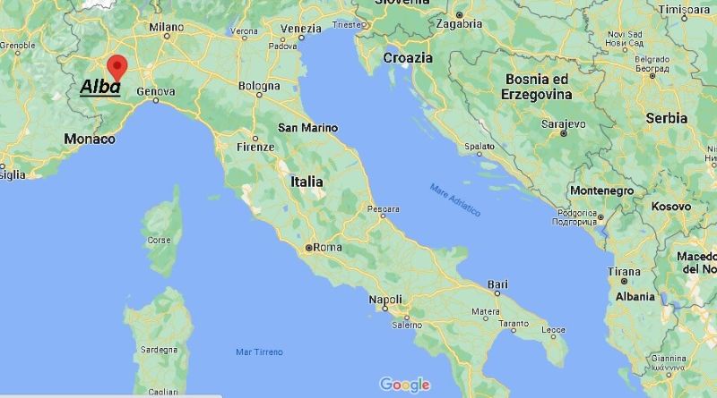
Italy, a country renowned for its rich history, stunning landscapes, and cultural heritage, is located in Southern Europe. Its distinctive boot-shaped peninsula is surrounded by the Mediterranean Sea, and it is bordered by France, Switzerland, Austria, and Slovenia to the north. A map of Italy offers a visual insight into the country’s geographical layout, showcasing its diverse regions, iconic landmarks, and famous cities.
Table of Contents
Key Features of a Map of Italy
- Geographical Layout:
Italy is divided into 20 regions, each with its own unique culture, history, and cuisine. The country’s map highlights these regions, which are further subdivided into provinces. The northern regions, such as Lombardy, Veneto, and Piedmont, are known for their mountainous terrain, including the Alps. The central regions like Tuscany and Lazio are home to beautiful rolling hills, while southern regions like Sicily and Calabria offer coastal views and Mediterranean climates. - Capital and Major Cities:
Rome, the capital, is located in the central-western part of Italy and serves as the country’s political, cultural, and historical hub. Other major cities marked on a map of Italy include:
- Milan (in the north) – Italy’s fashion and financial capital.
- Florence (in central Italy) – Famous for its art, architecture, and history.
- Venice (in the northeast) – Known for its canals and historic sites.
- Naples (in the south) – A coastal city with ancient ruins and rich culinary traditions.
- Genoa (in the northwest) – A historic port city with a maritime heritage.
- Landmarks:
A map of Italy also includes famous landmarks such as:
- The Colosseum in Rome, an ancient amphitheater and one of the New Seven Wonders of the World.
- The Leaning Tower of Pisa, which is located in the city of Pisa, famous for its unintended tilt.
- Mount Vesuvius near Naples, an active volcano known for its eruption that destroyed the Roman cities of Pompeii and Herculaneum in AD 79.
- Natural Features:
Italy is blessed with stunning natural features, and these are often marked on maps. The Alps in the north provide scenic views and skiing opportunities, while the Apennine Mountains run down the length of the country, offering hiking and outdoor activities. The Po River, Italy’s longest river, flows through the northern plains, while Italy’s islands, including Sicily and Sardinia, are clearly marked on the map. - Coastlines:
The Italian peninsula has an extensive coastline along the Mediterranean Sea, with notable stretches such as the Amalfi Coast, Cinque Terre, and the island of Capri. Coastal cities like Genoa, Venice, and Naples are strategically positioned along Italy’s shores, making Italy a prime destination for beach lovers.
Why a Map of Italy is Useful
A map of Italy is incredibly helpful for travelers, historians, students, and anyone interested in Italian geography. Whether planning a vacation, studying the country’s regional differences, or simply curious about the geographical features, a map provides a clear and concise overview of the country. Here are some of the reasons why a map of Italy is important:
- Travel Planning: If you are planning a trip to Italy, a map helps you identify which regions or cities you want to explore, from the bustling streets of Milan to the peaceful countryside of Tuscany.
- Cultural Exploration: Each Italian region is known for its distinct dialect, food, traditions, and historical sites. A map allows you to better understand how these regions are connected and their unique characteristics.
- Geographical Knowledge: Italy’s complex topography includes coastal regions, mountains, plains, and islands. A map allows one to appreciate Italy’s geographical diversity.
Frequently Asked Questions (FAQs)
1. What are the major cities in Italy?
The major cities in Italy include Rome (the capital), Milan, Florence, Venice, Naples, Turin, Genoa, Bologna, and Palermo.
2. What are the most famous landmarks in Italy?
Some of Italy’s most famous landmarks are the Colosseum in Rome, the Leaning Tower of Pisa, the canals of Venice, Mount Vesuvius, and the ancient city of Pompeii.
3. How many regions does Italy have?
Italy is divided into 20 regions, including Lombardy, Tuscany, Lazio, Sicily, and Campania.
4. What are the best places to visit in Italy?
Some of the best places to visit in Italy include Rome, Venice, Florence, the Amalfi Coast, Cinque Terre, Tuscany, Sicily, and the island of Capri.
5. What is Italy’s geography like?
Italy is characterized by its boot-shaped peninsula, the Alps in the north, and the Apennine mountain range running through the country. It also has beautiful coastlines, rolling hills, and islands such as Sicily and Sardinia.
6. Can I use a map of Italy for hiking?
Yes, a map of Italy can be a great resource for hiking, especially in regions like the Dolomites, the Apennines, and other mountainous areas. The map will help you navigate trails and understand the terrain.
Conclusion
A map of Italy is not just a geographical tool but also a gateway to understanding the cultural and natural beauty of this fascinating country. Whether you are planning a visit to Italy, studying its regions, or simply exploring its unique landscapes, a map will provide you with valuable insights into Italy’s diverse geography, cities, and landmarks.
